How Do Scientists Track Endangered Species in Remote Rainforests
I spent three weeks in the Sumatran rainforest watching researchers deploy GPS collars on sedated orangutans, and honestly, what struck me most wasn’t the dramatic rescue moment—it was the mundane reality afterward. Once that collar was fitted, the real work began: refreshing a satellite data portal every morning at 6 AM, interpreting a blinking dot on a map, and making decisions based on what that single animal told us about where the whole population might be hiding. This is how scientists actually track endangered species in remote rainforests. Not through hunches or helicopter surveys, but through a methodical toolkit of GPS collars, camera traps, acoustic sensors, and genetic sampling that turns invisible animals into measurable data points.
The gap between what people imagine and what really happens in conservation fieldwork is massive. Everyone knows we need to save endangered species. Few understand how researchers locate them in the first place—and fewer still appreciate the brutal cost and technical headaches involved.
GPS Collars and Real-Time Location Tracking
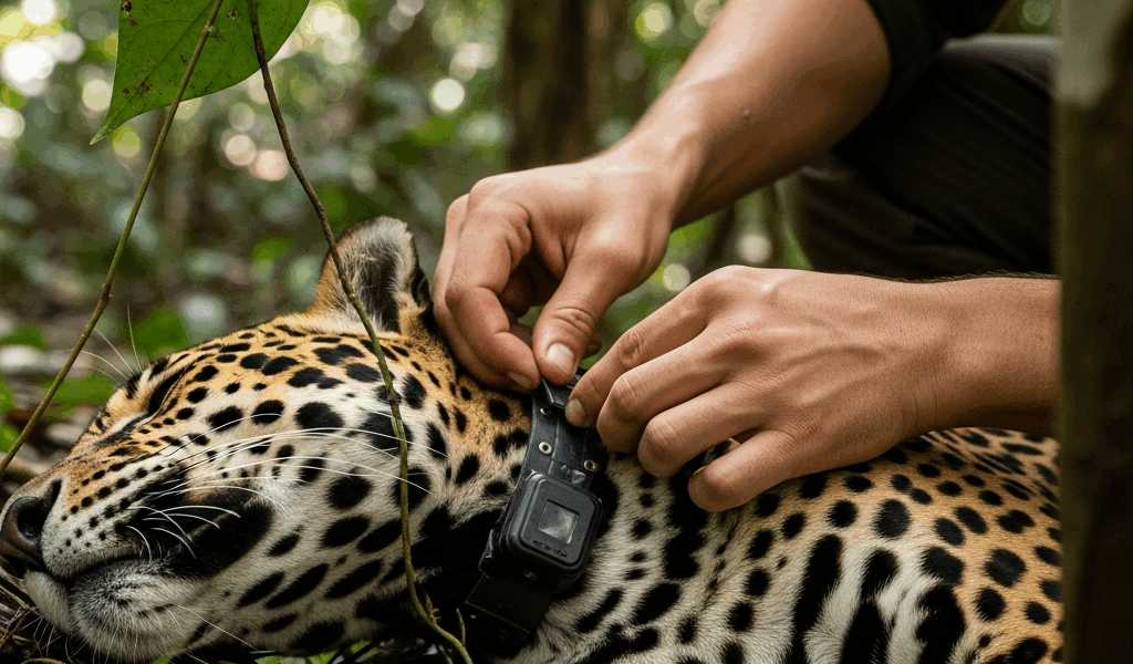
A GPS collar is essentially a small computer strapped around an animal’s neck. It weighs between 50 and 500 grams depending on the species, costs $2,500 to $8,000 per unit, and does one job obsessively well: recording geographic coordinates every few hours or every day.
Here’s how it actually unfolds in the field. Researchers sedate the target animal using blow darts or baited traps. They fit the collar around the animal’s neck or, for smaller creatures, attach it to a harness. Then comes the satellite transmitter—either a GPS/Argos system that bounces location data off satellites, or a more advanced GPS/GSM collar that sends data via cellular networks when signal exists.
The satellite-based systems work even in dense rainforest where cell signals vanish. That matters. A Sumatran rhino wearing a $7,000 Argos collar in Malaysia’s Taman Negara reserve sends location pings back to researchers’ laptops every 12 hours. The accuracy hovers around 100 to 500 meters — which sounds precise until you’re standing in jungle where 500 meters means crashing through vegetation for an hour without seeing anything.
Battery life becomes the real headache. GPS collars drain power constantly. A typical collar runs for 18 to 36 months before the batteries die and the collar simply stops transmitting. Some newer models use solar panels to extend lifespan to four or five years, but dense canopy blocks most sunlight. Researchers must choose: deploy the collar for a longer mission on a larger, slower-metabolism animal, or use a shorter-duration collar on smaller species where you need frequent location updates to understand movement patterns.
The cost barrier is brutal. Tracking 20 jaguars across a Central American corridor costs $160,000 just in hardware over four years. Add in the salary of the field biologist who sits refreshing data daily, the veterinarian who captures and collars the animals, and replacement collars for animals that lose them to poaching or accidents. A single longitudinal study easily exceeds half a million dollars.
Probably should have opened with this section, honestly — GPS collars remain the gold standard for understanding large carnivore movement, social behavior, and habitat use because they provide continuous, precise tracking data that no other method matches. But they only work for animals large enough to carry the hardware. You can’t collar a frog. You can’t collar a tree snake. You can’t collar anything smaller than a house cat, realistically.
Camera Traps and Motion-Activated Photography
This is where the revolution happened. Camera traps cost $200 to $800 per unit and require zero animal handling. Deploy them and walk away.
Positioned strategically along game trails, at water holes, and near den sites, these weatherproof boxes contain a motion sensor and a camera. When an animal walks past, heat or infrared movement triggers the shutter. A single camera trap can generate 50,000 images per month in active rainforest.
Placement strategy determines everything. Researchers study track patterns, scat deposits, and local knowledge from indigenous guides to identify corridors where endangered animals actually move. In jaguar research across Guatemala’s Petén region, scientists positioned cameras roughly 500 meters apart along a north-south corridor connecting reserve areas. Over 18 months, they documented 17 individual jaguars — distinguished by facial spot patterns unique to each animal. They discovered breeding pairs, tracked juvenile dispersal, and proved that a population believed to be isolated actually maintained connectivity with another population 40 kilometers away.
The technical challenges are real and annoying. Rainforest humidity corrodes electronics. Cameras get stolen. Water seeps into battery compartments despite “weatherproof” designs. Ants and spiders nest inside the sensor housing. Researchers must check cameras every 30 days, replace corroded batteries, and deal with the massive data management problem: thousands of images containing mostly vegetation, insects, and leaf-drop false positives.
Software has partially solved the identification headache. AI-powered image recognition tools now scan thousands of photos and flag animal images automatically, sorting them by species. For individual identification, researchers still rely on manual inspection — pattern-matching jaguars by spots, elephants by ear tears, tigers by stripe configurations. But this work is now crowdsourced. Conservation nonprofits run platforms where citizen scientists classify camera trap images, turning a labor-intensive bottleneck into something scalable.
One advantage camera traps provide that GPS collars cannot: they reveal entire communities. A single camera captures jaguars, peccaries, tapirs, ocelots, and margays in sequence. Researchers begin understanding predator-prey relationships and forest health through species composition at each site. This ecosystem-level data costs nothing extra once cameras are deployed.
Acoustic Monitoring and Bioacoustic Analysis
In the Yasuni rainforest of Ecuador, researchers faced an unsolvable problem. They needed to monitor seven primate species, two howler monkey subspecies, and several tanager species across 10,000 hectares. GPS collars were impractical for small arboreal primates. Camera traps missed canopy-dwelling animals entirely.
They deployed autonomous recording units — essentially weather-sealed microphones powered by solar panels and connected to hard drives. Each unit recorded continuously for months, capturing every sound in a 100-meter radius. Then they fed the audio files into bioacoustic software trained to recognize species by vocalizations.
This is extraordinary for two reasons. First, it works in conditions where other methods fail. You cannot GPS-collar a tree frog. You cannot photograph a howler monkey hidden in dense canopy. But you can hear it calling at dawn from a kilometer away. Second, vocalizations reveal behavior and population structure. A male howler’s roar carries information about territory, mating status, and health stress that location data never captures.
The software part is still emerging and frustrating. Tools like BirdCLIP and PAMGUARD can identify some species reliably, but false positives remain problematic. Rain noise, wind through canopy, and insect calls create acoustic clutter. One research team in Peru found their acoustic monitoring system flagged 300 calls per hour as “potentially peccary” when the actual false positive rate was 40 percent. They spent months training the algorithm on local vocalizations before accuracy exceeded 85 percent.
Battery and storage become limitations. A single recording unit generates 20 gigabytes of audio per week. Deploying 50 units across a landscape creates a terabyte of data monthly. Most field stations lack reliable internet to upload this volume. Researchers must physically retrieve hard drives by canoe or helicopter — a process that’s expensive and weather-dependent.
DNA and Scat Sampling for Population Estimates
Captured by necessity, a jaguar researcher in Brazil realized something obvious in hindsight: you don’t need the animal itself to know where it is. You need its feces.
Fecal DNA sampling requires no animal contact and minimal equipment — collection bags, gloves, and a freezer. Researchers walk transects through rainforest, collect fresh scat (identifiable by odor and shape), and mail samples to a genetics lab. DNA extracted from scat reveals not just species identity but individual identity. Hair follicles and intestinal epithelial cells contain unique genetic markers. A single fecal sample can identify which jaguar deposited it, its sex, its genetic relatedness to other individuals, and population-level genetic diversity.
This is especially powerful for estimating actual population size. Traditional visual surveys dramatically undercount cryptic species. Fecal DNA combined with capture-recapture statistics — the same individual’s scat collected at different locations, different times — provides robust population estimates. In one study of Pantanal jaguars, scat-based genetics revealed a population of 31 individuals when previous camera-trap surveys estimated 18. The difference altered conservation priorities entirely.
Humidity is the enemy. Rainforest environments degrade DNA rapidly. Bacterial contamination increases. Fungal growth destroys samples within days, not weeks. Researchers must use specialized preservatives — ethanol or silica gel drying — and get samples to a lab within two weeks in tropical conditions. Once they started using field freezers powered by solar panels and hiring local guides to collect scat daily, success rates jumped from 40 percent to 85 percent.
Cost remains high. Per-sample genetic analysis runs $40 to $100. Processing DNA from 500 scat samples for a single landscape monitoring project costs $20,000 to $50,000. But population estimates from DNA are accurate in ways that visual surveys cannot achieve, particularly for solitary, nocturnal, or arboreal species.
Why These Methods Matter More Than You Think
The real insight isn’t that we have fancy technology to track animals. The insight is that methodology transparency makes conservation credible. When researchers publish that they tracked jaguars using GPS collars on 12 individuals plus camera traps at 40 sites plus acoustic monitoring at 15 stations plus DNA sampling of 300 scat samples, skeptics cannot dismiss the data as anecdotal.
Accurate monitoring prevents catastrophic interventions. In 2015, a conservation program spent $8 million translocating a “threatened” population of howler monkeys in Mexico. Later analysis showed the population had been stable for a decade — previous population estimates simply used unreliable visual surveys. Combined methodology would have caught this. GPS collars + camera traps + acoustic surveys would have revealed population trajectory clearly.
Choosing the right tool for each species and habitat is the actual skill. Tracking aquatic species requires telemetry receivers in boats rather than satellite systems. Small-bodied species need acoustic monitoring or genetic sampling rather than collars. Budget-constrained work relies on camera traps alone, accepting lower precision in exchange for broader geographic coverage.
The scientists succeeding in rainforest conservation research aren’t the ones with the biggest budgets or the fanciest technology. They’re the ones who understand these methods deeply enough to combine them strategically, knowing the tradeoffs of battery life versus accuracy, GPS precision versus cost per individual, and temporal resolution versus spatial coverage. That’s how invisible animals become visible enough to save.

Leave a Reply