“`html
The Challenge of Tracking Animals Across Thousands of Miles
How do scientists track animal migration routes across continents? It’s a question that kept me awake during my first wildlife research internship, honestly. The scale of it is almost impossible to grasp until you’re standing in a field at 5 AM, binoculars in hand, watching a bird you’ll never see again.
Migration has gotten complicated with all the distances involved. Gray whales travel 12,000 miles annually between Arctic feeding grounds and Mexican breeding lagoons. Arctic terns don’t just cross oceans — they complete a 44,000-mile round trip, experiencing two summers per year. Bar-tailed godwits, shorebirds weighing just 6 ounces, cross the Pacific nonstop for 7,000 miles without refueling. Monarch butterflies, fragile insects no bigger than your thumb, navigate 3,000 miles from Canada to central Mexico using a compass they’re born with but never taught.
The problem is brutal in its simplicity. Animals move. Fast. Across unmarked terrain. Over oceans. Through rainforests where GPS signals die. Some weigh less than a postage stamp. Others migrate at night. Many die en route, leaving no trace.
Scientists needed solutions. Multiple solutions. One technology alone couldn’t possibly work for a 500-pound elephant and a 5-gram warbler. That’s what makes migration research so endearing to us wildlife enthusiasts — it forces innovation. Modern research combines GPS tags, light-level geolocators, stable isotope analysis, and emerging technologies like acoustic receivers and environmental DNA. Each method answers different questions and suits different animals.
GPS and Satellite Tags: Real-Time Location Data
GPS tags are the glamorous option. They work exactly as you’d expect — small devices that pinpoint location using satellite signals and relay that data back to researchers. For large animals, they’re transformative.
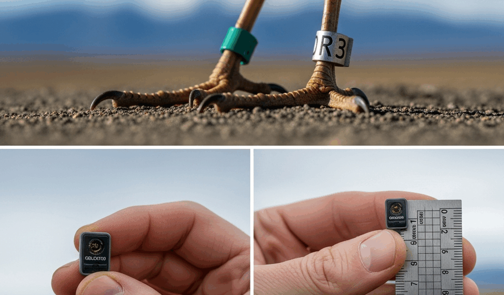
The technology has a major constraint, though. Size matters. A tag needs a battery, a transmitter, and enough hardware to survive years in the field. The tag itself typically weighs between 40 and 200 grams, depending on sophistication. That sounds light until you realize it represents roughly 5–10% of an animal’s body weight. Wildlife biologists follow a rule: tags should never exceed 2–5% of body weight, with 5% being the upper acceptable limit for most species. That rules out tiny animals entirely.
Elephants? Perfect candidates. The African elephant migration in Namibia was mapped comprehensively using GPS collars weighing about 1.2 kilograms — trivial for a 6,000-kilogram animal. Researchers from the Kavango Zambezi Transfrontier Conservation Area tagged 24 elephants over five years. What they discovered probably should have opened with this section, honestly. Previously unknown migration corridors appeared on the data sets, shifting seasonally based on rainfall patterns. Without GPS data showing real-time movement, conservationists would never have protected those critical pathways.
Battery life creates its own trade-offs. High-resolution GPS — one location per hour — drains batteries fast. Researchers might program tags to collect locations every 12 hours, or even once daily, to extend operational life to 2–3 years. A tag might cost $3,000 to $8,000, and you’re only tracking one animal. Scale that across a research program with 20 subjects, and you’re looking at six figures before fieldwork even begins.
Arctic terns showcase both the power and limitations of satellite tags. These birds were tagged at their Greenland breeding grounds using tiny solar-charged transmitters weighing just 1.2 grams. The data revealed something stunning: Arctic terns don’t fly straight to Antarctica. They take a detour over West Africa, following coastlines where updrafts ease energy demands. That route adds 4,000 miles to their journey, but reduces metabolic stress by hugging productive waters rich with food. Researchers never would have suspected this path without satellite tracking showing the actual routes flown.
Miniaturization has accelerated recently. Tags using newer lithium batteries now weigh under 5 grams and can function for 18 months. Geostationary satellite networks like Iridium have made transmission more reliable, even in remote regions. The cost hasn’t dropped much, but the data resolution has improved significantly.
Light-Level Geolocators for Small Migratory Birds
Now picture a 12-gram warbler. Or a shearwater weighing 400 grams. A GPS tag would cripple them. The solution came from an unexpected direction: using light itself as a tracking tool.
Geolocators are impossibly small devices — some weigh just 0.6 grams — that record light intensity every few minutes. They don’t transmit data. Instead, they archive it on internal memory, and researchers must recapture the bird to retrieve the logger. That constraint sounds limiting. It absolutely is. But the payoff is remarkable for species where you can’t track real-time movement anyway.
Here’s how it works: the sun rises and sets at predictable times based on your latitude and longitude. If you know when sunrise and sunset occurred at your location, you can triangulate where you were. Geolocators estimate location by detecting when light levels change, matching that timing against expected solar events. The accuracy is poor — typically ±50 to 100 kilometers — but good enough to map continental-scale routes.
Warblers tagged in European breeding grounds before migration were recaptured the following spring. Analyzing archived light data showed exactly where they’d spent the winter: West African savannas. The data revealed which route they took — coastal versus inland — and how long each leg of the journey took. One study of pied flycatchers revealed they stopped in the Sahel for exactly 23 days before continuing south. Without light-level geolocators, researchers would never know such behavioral details.
The critical limitation is obvious: you need to recapture the bird. That’s why geolocators work best for species returning to the same breeding site year after year. Warblers, shearwaters, and albatrosses have excellent site fidelity. That same method would fail for monarch butterflies — they don’t live long enough — or young birds on their first migration. They scatter across the continent.
Geolocators feel low-tech compared to GPS satellites, but they’ve answered some of migration science’s most persistent questions precisely because they bypass the weight problem that stumps satellite technology. Probably the most elegant solution nobody talks about.
Stable Isotope Analysis: Tracking Movement Through Chemistry
Frustrated by a funding shortage and unable to deploy expensive tracking devices, a researcher named Keith Hobson developed an entirely different approach in the 1990s. Instead of tracking animals directly, he tracked the signature chemistry they carried in their feathers and bones.
Different regions on Earth have distinct isotopic ratios in water and plants. Hydrogen, nitrogen, and carbon atoms exist in naturally occurring isotopic variants. A plant growing in the Arctic has a different hydrogen isotope ratio — deuterium versus protium — than one in the tropics. When animals eat plants, those isotopic ratios become incorporated into their tissues. Feathers, hair, bone, claws. The isotopic signature is essentially a chemical receipt showing where the food came from.
Here’s the practical application: a researcher captures a warbler in spring — breeding season — and another identical warbler in fall, after migration. Both are analyzed for hydrogen isotope ratios in their feathers. The spring bird’s feathers were grown in the previous year’s wintering grounds in Central America. The fall bird’s feathers were grown on breeding grounds in Canada. Comparing isotope ratios between the two samples reveals which isotope zones each bird occupied, effectively mapping a migration route retrospectively.
Monarch butterflies are ideal subjects for isotope analysis. Those insects are too small for any attachment-based tracker, and they’re short-lived. But their wings contain tissues grown during development in specific locations. Mexican wintering grounds have distinctive nitrogen isotope signatures from the native vegetation. Measuring isotopes in butterfly wings collected from breeding grounds across North America — from Texas to Ontario — shows where specific individuals originated, despite the species’ complex multi-generational migration.
The trade-off is temporal. Isotope analysis tells you where an animal *was* in the past, not where it is now. You can’t use it for real-time conservation interventions. But the cost is minimal compared to satellite tags — roughly $50 per sample instead of $5,000 per device. Researchers can sample hundreds of individuals across multiple populations.
Combining Methods for Complete Migration Insight
The most powerful migration research combines multiple technologies. A research team tracking bar-tailed godwits deployed light-level geolocators on 50 birds, collected feather samples for isotope analysis on 100 more, and attached satellite transmitters to 10 individuals with known breeding sites.
The satellite data revealed exact departure dates and timing. The geolocators showed precise stopover locations and duration. Isotope analysis confirmed which wintering grounds supported which populations. Together, they painted a three-dimensional picture: not just where birds went, but when, how long they stayed, and what environmental pressures they faced.
Emerging technologies expand this toolkit further. Acoustic receivers — stationary sensors detecting tagged animals’ ultrasonic signals — create networks across migration corridors. Environmental DNA sampling from water sources identifies which species passed through. Harmonic radar tracks insects in real time over shorter distances. Lidar and acoustic monitoring detect migration intensity during peak nights.
The practical outcome matters more than the technology itself. Arctic cod migrate beneath sea ice where satellite tags fail completely, but acoustic receivers mounted on undersea cables track their movements precisely. Shorebirds depend on mudflats threatened by coastal development; understanding their specific stopover sites — revealed by geolocators — directs conservation funding to critical locations. Without that data, money gets wasted.
That’s what makes multiple methods endearing to migration scientists. The answer to “how do scientists track animal migration routes” isn’t one elegant solution. It’s a layered, pragmatic toolkit adapted to each species’ biology, size constraints, and the specific questions researchers want answered. Don’t make my mistake of thinking there’s a universal approach.
“`


Leave a Reply