Why Tracking Ocean Whales Is So Different From Land Animals
How do scientists monitor whale populations in open ocean? The short answer: they’ve had to get creative. As someone who spent three years following marine biology research at a coastal lab in Maine, I watched firsthand why traditional tracking methods fail spectacularly on cetaceans. Land mammals are manageable — you can collar a moose, slap a GPS device on a bear and watch its coordinates stream into your database. Whales? Completely different problem.
The ocean is massive. A blue whale might migrate 12,000 miles annually across multiple international waters. They dive to depths where GPS signals die instantly. Metal collars corrode in saltwater. Animals that surface for three seconds per hour aren’t stationary targets — even satellite tags, which work on penguins and seals, struggle with large baleen whales because the animals’ curved heads won’t hold the attachment sites reliably.
That’s what frustrated researchers decades ago, pushing them to abandon the traditional collar-and-monitor approach entirely. Instead, they developed five parallel methodologies that work together like a mosaic — each revealing different pieces of the population puzzle. The real insight isn’t that scientists use one magic solution. It’s that they layer multiple imperfect methods to create something actually useful.
Acoustic Monitoring With Hydrophone Networks
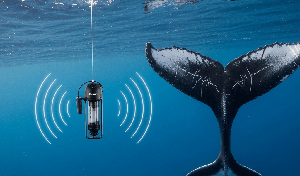
A hydrophone is basically an underwater microphone. Think of a specialized underwater speaker, except reversed — it listens instead of broadcasts.
Whales are loud. Humpback songs travel for miles through ocean water. Blue whales produce 188-decibel clicks that can propagate across entire ocean basins. Fin whales call at frequencies humans can’t hear. This constant acoustic signature became the foundation for population monitoring that doesn’t require seeing the animal at all. Probably should have opened with this section, honestly, since it’s the simplest to explain.
Researchers deploy arrays of these hydrophones — sometimes dozens, sometimes hundreds — across migration routes and feeding grounds. JASCO Applied Sciences (a company I learned about while researching underwater sound) manufactures autonomous seafloor-mounted hydrophones that record continuously for months. NOAA maintains the Ocean Observatories Initiative, a network of underwater listening stations capturing everything from whale calls to shipping noise to undersea earthquakes.
The data collection is straightforward. Hydrophones record acoustic signals. Researchers use specialized software to identify whale calls by frequency pattern and timing — a blue whale’s 20-hertz pulse-train is unmistakable, while fin whale “70-hertz calls” are equally distinctive. When that call pattern shows up on multiple hydrophones with slight timing differences, researchers triangulate the whale’s location underwater without ever seeing it.
Here’s where it gets powerful: call density reveals population size. If acoustic monitoring stations detect a specific whale call pattern 1,200 times per week in a feeding zone, and you know individual whales typically call 30 times per week, basic math gives you population estimates. The method isn’t perfect — some whales stay silent, water conditions affect sound transmission — but it’s continuous and covers regions where aerial surveys become impossible.
One real example: researchers studying endangered North Atlantic right whales have reduced their reliance on costly aerial surveys by integrating acoustic data from moored arrays. They now detect migration timing and know when whales arrive in coastal zones weeks before traditional visual observation methods would spot them. This matters for ship strike prevention, which kills three to four right whales annually — deaths that matter when your species counts in the hundreds.
Aerial Surveys and Drone Technology
For decades, whale monitoring meant scientists standing on ships with binoculars and clipboards. Researchers would sail transect lines — imaginary grids across the ocean — scanning the surface for whale blows, that water spray from exhalation. A trained observer can spot a spout from miles away. They’d record species, number of animals, calf presence, and direction of travel. Multiply that across hundreds of survey days per season and you get population trends.
This method works but carries real problems: observer bias, weather disruption, vessel disturbance to whales, and cost. A research vessel runs $30,000 to $50,000 per day to operate. That’s before fuel, permits, or staff salaries.
Enter drones. In the last decade, fixed-wing aircraft and quadcopters revolutionized whale surveying. A drone covers the same transect route in one-tenth the time, operates in rougher sea states, and captures high-resolution imagery from angles impossible from a ship. Most importantly — it doesn’t disturb the animals.
Researchers working with drone operators discovered another advantage: altitude gives perspective. From 400 feet up, you can see whale behavior patterns — calves staying close to mothers, feeding groups clustering, mating balls gathering — that surface-level observation misses. The camera records everything. Later, researchers review footage frame-by-frame, counting individuals and documenting behaviors. A 2019 study using drones on humpback whales off Brazil counted 600 animals in waters where traditional methods had estimated 400 three years prior. That’s not a small difference.
The logistical advantage is underrated. Drones operate from small boats or coastal sites. You need a pilot, a spotter, and basic equipment — total cost roughly $5,000 to $15,000 per survey day compared to six-figure ship operations. This economic shift means researchers can survey more frequently, building seasonal datasets that reveal migration timing and population fluctuations previously invisible due to funding constraints.
Photo Identification and Individual Tracking
Whales have unique markings. A humpback’s tail fluke carries black and white patches unique to each individual — like a cetacean fingerprint. Sperm whales display distinctive scars and pigmentation. Killer whales develop notches in their dorsal fins over years. These marks accumulate through life experiences: boat strikes, entanglement injuries, predation attempts from orcas, fights over mating.
Photographers have been documenting whale markings since the 1970s. The Cascadia Research Collective maintains a catalog of over 4,000 identified humpback whales photographed across the Pacific. When a whale surfaces near a research vessel or in drone footage, photographers capture the distinctive mark. Back on land, they cross-reference the image against existing catalogs using pattern-matching software and human verification.
The magic happens when the same individual appears in two locations years apart. A humpback photographed off Alaska in summer, then resighted off Hawaii that winter, confirms migration routes. An animal photographed off Maui in 2015 and again in 2023 indicates population persistence and reproductive success. Compile decades of these sightings and you create movement maps showing where populations go, how long they spend in each region, and whether they return consistently.
Photo-ID provides what acoustic and aerial surveys cannot: individual-level data. You’re not just counting whales. You’re tracking specific animals, learning their life histories, observing them through multiple births. For endangered species like North Atlantic right whales, the U.S. maintains a photo-ID catalog with identified individuals named and tracked from calf to adulthood. When a right whale dies — from a ship strike or fishing gear — researchers know exactly which individual was lost, what reproductive value they represented, and how it affects population trajectory.
The limitation is effort. Photo-ID requires clear markings visible in usable light, close enough proximity to photograph clearly, and labor-intensive catalog maintenance. But for population viability analysis — the statistical models that predict whether a species will recover or go extinct — individual-level data is invaluable.
Genetic Sampling and Biopsies
Scientists armed with crossbow-like equipment shoot small biopsies from whale skin and blubber. Yes, actually shoot them. A specially designed bolt carries a hollow tip that collects a pencil-eraser-sized sample traveling at impact speeds that cause minimal injury. The whale flinches. The sample drops into a retrieval net behind the boat. This seems invasive, honestly, but in practice it’s remarkably low-impact — the wound is smaller than the whale would receive from natural causes like parasites or rope entanglement.
Genetic analysis of these samples reveals population structure, migration histories, and breeding patterns invisible to visual methods. DNA fingerprinting identifies closely related whales, showing which males fathered which calves. Mitochondrial DNA tracking traces maternal lineages backward through generations, revealing whether populations have distinct breeding stocks or mix freely. Genetic health indicators — allele diversity, inbreeding coefficients — show whether a population is genetically viable or collapsing toward extinction from low genetic diversity.
For right whales, genetic sampling proved something sobering: only about 500 females of reproductive age exist. Prior population estimates guessed 800 to 1,000. This genetic reality sharpened conservation priorities dramatically. Every reproductive female matters. Loss of even one matriline — a maternal lineage — reduces genetic diversity. This knowledge drives shipping lane restrictions and fishing gear regulations.
The process requires coordination: researchers must obtain permits, find the whales, successfully collect samples, transport them to labs under controlled conditions, and run DNA analysis. That’s a 6-to-12-month process per sample. It’s expensive and labor-intensive, but it provides data nothing else can match. Don’t make the mistake of thinking this is just academic work — the information directly shapes whether a species survives the next century.
Scientists combine all five methods because each captures different dimensions of population status. Acoustic monitoring shows real-time presence and calling behavior. Aerial surveys count animals rapidly across broad areas. Photo-ID builds individual histories. Genetic sampling measures population health at the molecular level. Without further ado, together they answer what actually matters: How many whales exist, where are they going, are they reproducing, and will they survive?




Leave a Reply